
Mapa Mural De África Para Niños De Collins - 19,5 X 30 Pul
en 12x sin interés
Llega gratis el miércoles 12 de junio
Disponible 24 días después de tu compra
¡Última disponible!
MercadoLíder | +1000 ventas
- Tienes 30 días desde que lo recibes.
Compra ProtegidaSe abrirá en una nueva ventana, recibe el producto que esperabas o te devolvemos tu dinero.

MercadoLíder
+1000
Ventas concretadas

Brinda buena atención
Medios de pago


Características del producto
Características principales
Marca | MapSherpa |
|---|---|
Modelo | Unico |
Color | Multi |
Descripción
Bienvenid@,
Traemos lo que quieras, en menos de 25 días hábiles.
TÉRMINOS Y CONDICIONES
------------------------------------------
- Fotos referenciales del producto, consulte no mas
- Despachamos a todo Chile con Starken o Mercado Envios
- Productos importados de Estados Unidos, es probable que los productos electronicos trabajen en 110V y NO en 220V, podria usar un transformador, para mas informacion primero nos puedes preguntar todas las inquietudes que tengas.
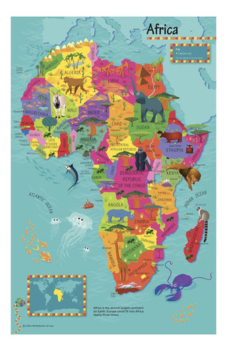
Mapa mural de África para niños de Collins - 19,5 x 30 pulgadas - Papel
Collins Children's Africa Wall Map - 19.5 x 30 inches - Paper
COLOR: Multi
MODELO: UNICO
MARCA: MapSherpa
TALLA: Paper
-LEARN AND DISCOVER: A simple yet informative map, allowing children to explore and learn about the African continent
-FUN AND MEMORABLE: Fun colors and familiar illustrations will make it easy for children to learn and retain facts about different animals, foods, etc.
-TRUSTED PUBLISHER: Collins has been publishing educational and informative books since 1819. Throughout this rich heritage they have maintained an impressive record in creating market-leading products across various sectors.
-HIGH QUALITY PRINT: Printed on thick paper suitable as a poster for display on your home, school or office wall.
-ROLLED IN A STURDY TUBE: Your map is rolled and packaged in a sturdy tube to protect it during shipment
This highly illustrated pictorial map is designed to take children on a journey of discovery around the countries of Africa. The mapping is clear, colourful and highly informative and shows countries and capital cities. Stunning illustrations are used to depict themes such as national emblems, customs, food, birds, animals, buildings and sports to help younger readers gain an understanding of peoples around the world. The perfect introduction to maps for 4-8 year olds. Illustrated by Steve Evans. 19.5 x 30 inches. Printed on high quality thick paper strong enough for display on your wall. Your map is rolled and packaged in a sturdy tube to protect it during shipment. B0BLHXVZPQ
Garantía del vendedor: 90 días
Preguntas y respuestas
¿Qué quieres saber?
Pregúntale al vendedor
Nadie ha hecho preguntas todavía.
¡Haz la primera!